The Willapa Hills Trail is a 56-mile trail link between the central I-5 corridor and the Pacific coast that offers a challenge for just about any cyclist.
Starting in Chehalis, Washington and ending in the town of South Bend on the Willapa Bay, not far from the ocean, the trail was once a railroad that has since been converted to trail use by Washington State Parks. More and more people have been discovering the trail in the past decade, and use is steadily increasing as people discover this gentle trail that offers a break from city life.
The Willapa, or WHiT as I like to call it, offers a great opportunity to get a great bike ride in without having to worry about traffic. It’s close enough to amenities and yet far enough to feel like you’re going somewhere new.
Hopefully if you’ve found this post, you’re looking for some info on the trail in consideration for an upcoming visit. My goal is to help you prepare and ensure you’re good to go with what you need to tackle this journey.
All information on this page is current as of February 17, 2025.
Who Is This Guy Anyway?
Oh hey, in case we’ve never met, I’m Chris Brewer, an avid cyclist who lives in Lewis County. I have biked the entire trail from Chehalis to South Bend and back multiple times, and done multiple segments of the trail hundreds of times since 2015.
In case you’re still wondering if I know about what I’m talking about: I’m the former board president of the Lewis County Community Trails Association, a group that enjoys a fantastic partnership with Washington State Parks and works hand-in-hand to help provide grant funding and much more. I’ve ridden more than 53,000 miles since I started biking in 2012, with thousands of miles logged on rail-trails and scenic routes here in Washington state.
I also directed the annual Ride the Willapa bike ride on the WHT from 2018 to 2024. My love for this trail and this section of the world runs deep, and as such I hope you feel the same appreciation I do for this recreational gem when you read this and ride the trail on your own time.
Honoring the Past: The Northern Pacific Railway’s South Bend Branch
The Willapa Hills Trail is a converted railroad corridor that once served as the primary means of transportation between Chehalis and Willapa Bay. Before cars were available to the general public, trains were king, and as such, the South Bend Branch of the Northern Pacific Railway was a lifeline that connected small communities to the world.
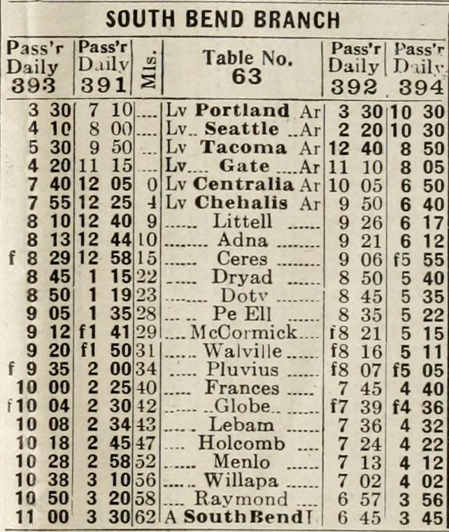
Completed in the late 1800s, the South Bend Branch brought trains through several communities we are familiar with today and others that died when the logging craze fizzled as the Great Depression neared. A timetable from 1911 indicates that there were a total of 19 stops and the journey took upwards of five hours to get from Centralia to South Bend.
In the railroad’s heyday, steam trains chugged along the tracks and brought people to and fro. Whether it was workers heading to work at one of the many mill towns along the railway’s 56-mile length, people visiting family and friends, or even folks heading into Chehalis to see President Taft — the train was the way to get to where you needed to go.
Increased use of the automobile, the timber industry decline in the late 1920s, and other factors forced Northern Pacific to begin curtailing service in the early 1930s. By 1954, with the Ocean Beach Highway from Chehalis to Raymond now being the primary means of travel, passenger use all but ended. In the early 1990s, the last train made its way along the tracks as Burlington Northern declared the line abandoned.
Washington State Parks assumed ownership of the corridor in 1993 with help from the Rails-to-Trails Conservancy. Since that time, they’ve been working hard to build the trail all the way through — and we’re almost there!
For more history, check out this blog post on Washington State Parks’ Willapa Hills Trail website.
What to Bring and Consider
The key to a successful journey on the Willapa Hills Trail, as with just about any bike ride, is proper preparation, planning and packing. You’ll want to be outfitted with proper gear and sustenance to make a 56-mile journey; in this particular instance, a non-negotiable is a bike with wide tires for starters.
Here’s what I bring on each trip:
My gravel bike: Giant Revolt 2 Advanced with 700x40c or 50c tires
Two bottles of water (I refill at a restaurant in Pe Ell and at the Menlo Store)
Sunscreen and extra chamois cream
Two extra bike tire tubes, two tire levers, and a bike pump
Portable charger and cords for phone, GPS head unit and watch
Here are some things you should consider:
The entire 56-mile trip will take you at least 5 hours of real time you’re in relatively good shape, and that’s just time in the saddle. Doing this in both directions will take an entire day at least. Plan for this as you travel, and consider having someone drop you off on one end and pick you up at the other; or camp out or get a hotel overnight in Raymond or South Bend and ride back the next day.
I’ll repeat this point: Several parts of the trail are difficult due to unimproved conditions. Remember to take breaks and rest where and when necessary. Conserve your energy, and gear down on sections that are either uphill or have deep gravel. Don’t be ashamed if you have to walk your bike through or around some sections, or if you have to re-route.
Always, always be respectful of landowners and people living adjacent to the trail. Respect goes a long way. Don’t make unnecessary noise and don’t litter. Basically, don’t be a jerk.
On the topic of littering: the WHT is a Leave No Trace trail. There are no garbage cans on the trail. If you generate trash, pack it out.
The Lay of the Land
Now a slight majority of the trail is in a condition the vast majority of people would refer to as “complete,” with refurbished bridges, compacted gravel, and rights of way improved for cyclists, pedestrians, and equestrians to enjoy. The entirety of the trail in Lewis County is feature-complete, while most of the trail west of the Willapa Hills in Pacific County requires a lot of work.
But I’ll have you know: You can ride nearly the entire Willapa Hills Trail in its current condition on any sort of bike.
It’s not the easiest journey, but it can be done.
Before I get into the granular details of what you’ll find along the trail, I want to show this Google map compiled by Wayne VanWeerthuizen, who founded the Willapa Hills Trail Fans group on Facebook. This is the most definitive map showing current trail conditions, and Wayne does a fantastic job updating it as conditions and construction change the complexion of the corridor. It has a LOT of info and is pretty exhaustive, so take your time with it.
If you, like me, appreciate the work Wayne has done on this map, please drop a note in the WHT Fans Facebook group and let him know.
Now onto the guide!